
Location: Gunung Liang, from Proton City, Behrang
Altitude: 1,933m ASL
Campsite: At the summit of Liang West, good for 3 tents. Campsite is open, beware of lightning.
LWP: 3 hours before summit at 1,300m ASL
Difficulty: 7.1/10 (http://danlow.multiply.com/journal/item/50)
Hike duration: 3D2N
Camera: Canon Powershot G10
Filter: NIL
Post editing: PS CS3
Members: Dan, James, Mickey, Chee Siang, Triptipal Singh, Lee Pui Mei
My reason to go there: Never been there, love to see what the place is like. I miss hiking mountains, camping, leeches, sandflies, water points, cooking, sleeping under the flysheet, my GPS, the feeling, etc…
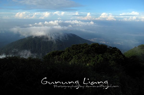
view from the summit of Liang West

like a cluster of corals

some pretty nice mossy forest near the summit region

a patch of rain cloud

a relaxing evening at the summit of Liang West

armor plated insect, very prehistoric looking, perhaps they didn't change much since billions of years ago

Genting highlands can be seen on a clear sky day .. from Liang

a cluster of mushrooms, they are poisonous I think

laichee looking fruits are the fruits of the Rotan(we use to make furniture)

a break by the river, members busy removing leeches from their legs

The map .. it all started from Proton City, Behrang
Date & Time Altitude Notes
9/16/2011 8:14 179 m Getting to the starting point can be done by car, however the road condition is not good, so a 4WD would be ideal. A new car will be painful, however u can still get there with an old car… :) There is ample space for perhaps 5-8 cars. The trail started at a small water collection area, sort of a small dam. The trail is clear, there are 4 river crossings and a lot of leeches.
9/16/2011 13:28 1298 m LWP is easy to spot, marked by empty water bottles. The area above the LWP is a nice flat area, good for 10 or more tents
9/16/2011 16:34 1933 m Arrive at the summit of Gunung Liang West, camping space is rather limited, good for perhaps 3 tents. The view from here is great.
9/17/2011 9:26 1933 m The next morning, we leave Gunung Liang West and headed north in search of Gunung Tumang Batak. Non of us have been there.
9/17/2011 9:34 1933 m Few minutes from Liang West, there is Liang East which stands equally tall as its twin(Liang West, 1933m). Unlike Liang West, the Beirut of Liang East is covered within tall mossy forest trees, it is very pretty up there.
9/17/2011 10:42 1686 m So we headed north-west, the trail was covered with thick vegetation at many areas, cutting our way thru ferns, rotans, fallen trees, etc was energy draining. .. However all looks ok until the trail started to turn west and it was descending following a ridge, we knew obviously we were on the wrong trail, further check on our GPS contour map confirms that, so we decided to make a U-turn..
9/17/2011 11:13 1801 m Back tracked to an earlier junction, and got back on the correct path…… more chopping ….
9/17/2011 11:37 1697 m Reach another junction; we took a gamble with the right path… and more chopping….
9/17/2011 12:06 1657 m Damn after 20 mins, we knew it was the wrong one again, as it was going down on another ridge …. So we made a U-turn again…
9/17/2011 12:25 1695 m We back track and returned to the earlier junction, I decided to return to the campsite at this point, I figure that even if we were able to find the correct trail to Tumang Batak at this point, it will be dark before we could return to the campsite. Triptipal Singh followed me back to the campsite. James wanted to push on, Mickey and Chee Siang followed James. (We reach camp at about 1:30pm). I handed my GPS unit to James, as my unit has contour map on it.
9/17/2011 13:27 1823 m James, Mickey & Chee Siang continued and reach an unknown peak, which is on the correct way to Tumang Batak. However Mickey and Chee Siang decided to return to campsite there. James pushed on alone. (Mickey & Chee Siang reach camp at about 3:30pm)
9/17/2011 15:36 1617 m James now only has about 20% more distant to cover, however as an experienced hiker, he knows time is not on his side and without a headlamp he has got to return. So James made a u-turn and return to campsite. (James reach camp at about 6:45pm)
9/18/2011 10:11 1933 m After a good night sleep and breakfast, we break camp and started the long descend journey
9/18/2011 15:33 180 m It was drizzling when we got to our cars, leeches were everywhere. After a fast clean up by the river we headed out to civilization and a good meal at Ulu Yam (Loh Mee and other local delicacies)
SLIDESHOW